In the age of technology, adventurers and nature lovers alike are discovering innovative ways to navigate the great outdoors. Gone are the days of traditional paper maps and compasses; now, we have powerful GPS devices and digital maps at our fingertips, making the process of tracking game more efficient and exciting. Whether you’re a seasoned hunter looking to improve your skills or a curious beginner eager to explore the wilderness, integrating GPS technology into your tracking toolkit can transform your outdoor experience. Imagine venturing into the wild with a trusty GPS device, feeling empowered by real-time data and precise navigation. In this article, we’ll guide you through the essentials of tracking game using GPS and digital maps, sharing tips, tricks, and the latest tech trends that will help you connect with nature in a whole new way. So grab your gear and let’s embark on this exciting adventure together!
Unlocking the Power of GPS: Why Every Hunter Needs a Digital Map Companion
Using GPS technology alongside digital maps revolutionizes the way hunters track their game. With real-time data at their fingertips, hunters can pinpoint their location, identify the lay of the land, and locate animal paths with impressive accuracy. This technology equips them with essential tools such as:
- Waypoints: Mark important locations like campsites, water sources, or game trails for easy navigation.
- Tracking: Monitor the movement of your game over time, allowing for better planning and timing during your hunt.
- Terrain Mapping: Understand elevation changes and landscape features, which can be crucial when considering animal behavior.
The benefits of integrating digital maps into your hunting strategy go beyond simple navigation. They enhance situational awareness and promote safety in the wilderness. Imagine the peace of mind that comes from knowing you’ll never lose your way or miss a prime hunting opportunity. With digital mapping tools, you can also:
- Share Locations: Collaborate with fellow hunters by sharing waypoints and routes seamlessly.
- Analyze Past Hunts: Use historical data to find patterns in animal movement, optimizing future trips.
- Custom Routes: Plan your journey by creating custom paths based on current weather conditions or scouting reports.
Quick Comparison of GPS Advantages
| Feature | Traditional Tracking | GPS & Digital Maps |
|---|---|---|
| Real-time Location | No | Yes |
| Sharing Coordinates | Limited | Easy |
| Data Analysis | Manual | Automated |

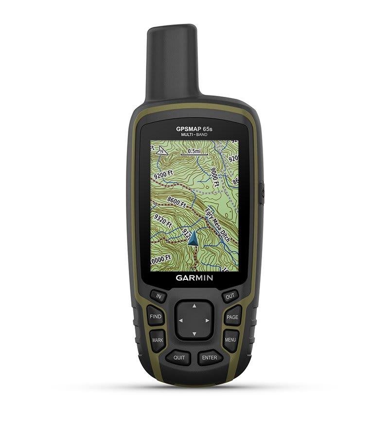
Choosing the Right Tools: Essential GPS Devices and Apps for Tracking Game
When it comes to tracking game, having the right tools can significantly enhance your experience. Consider investing in dedicated GPS devices that are designed specifically for outdoor navigation. These tools can provide precise location data, track your movements, and even help you mark waypoints of interest. Some of the top choices include:
- Garmin GPSMAP 66i – Combines GPS tracking with inReach technology for emergency messaging and navigation.
- Bushnell BackTrack Mini – A compact, user-friendly device perfect for beginners.
- DeLorme inReach Explorer - Offers two-way satellite text messaging and navigation features, ideal for remote locations.
In addition to standalone devices, mobile apps have become increasingly popular due to their convenience and functionality. Applications such as OnX Hunt, Gaia GPS, and HuntWise allow you to access digital maps, mark locations, and share routes with fellow hunters. Each application has unique features like:
| App Name | Features |
|---|---|
| OnX Hunt | Land ownership maps, offline mode, and custom waypoints. |
| Gaia GPS | Topographic maps, trip planning tools, and tracking capabilities. |
| HuntWise | Predictive analysis, weather updates, and community sharing. |
Utilizing these tools will not only keep you organized but also improve your success rate while tracking game, making every outing a more enjoyable and fruitful adventure.
Mapping Your Adventure: Techniques for Creating Effective Tracking Routes
When embarking on your tracking adventure, the first step is to familiarize yourself with GPS technology and digital maps. Start by choosing reliable mapping software that offers features like offline access, elevation profiles, and wildlife migration tracking. Here are some essential techniques you can employ:
- Set waypoints at strategic locations to mark areas of interest.
- Utilize tracks to trace your movements and identify frequently visited paths.
- Incorporate wayfinding tools such as compass modes and grid overlays for enhanced navigation.
Next, enhance your tracking routes by sharing and collaborating with fellow enthusiasts. Create a community-driven map where others can contribute data and insights about game movements. Consider these tips to improve collective efforts:
- Organize group outings to explore new terrains together, allowing for more comprehensive tracking.
- Host virtual meetups to discuss findings, share routes, and exchange tips on the latest tracking technology.
- Create a shared database of sightings and behavior patterns to identify emerging trends.
Staying Safe and Smart: Best Practices for Navigating the Wilderness with GPS
When wandering through the wilderness, it’s essential to maintain situational awareness while utilizing GPS technology. Begin with familiarizing yourself with your GPS device or app; knowing how to use all its features can prove crucial. Here are some best practices to consider:
- Regularly Update Maps: Ensure that your digital maps are up-to-date. Outdated maps can lead you astray.
- Set Waypoints: Mark important locations such as water sources, shelter spots, or notable landmarks. This can be a lifesaver.
- Battery Management: Always carry extra batteries or a portable charger, as GPS devices can drain quickly in the field.
- Backup Navigation Tools: In case of technological failure, bring a compass and a paper map as a backup.
Tracking game effectively requires a keen understanding of your surroundings, combined with the tools at your disposal. With the right approach, you can use your GPS to enhance your hunting experience. When mapping out potential hunting locations, consider the following:
| Feature | Importance |
|---|---|
| Water Sources | Animals often stay close to water, making it an essential spot for tracking. |
| Food Sources | Areas rich in vegetation or specific food sources can attract wildlife. |
| Game Trails | Identify and mark trails where animals frequently travel, increasing your chances of a successful hunt. |
| Elevation Changes | Understand how terrain influences animal movement; they may seek shelter on hills during extreme weather. |
Key Takeaways
As we wrap up our journey into the world of tracking game with GPS and digital maps, we hope you feel empowered to step outside and blend the wonders of technology with the thrill of the hunt. Embrace the harmony of nature and innovation, using the tools at your disposal to enhance your outdoor adventures. Remember, every step you take with your GPS is not just about the destination, but also about the stories you gather along the way—the whispers of the wind, the rustle of leaves, and the thrill of spotting wildlife in their natural habitat.
So grab your gear, charge up that GPS, and set forth on your next adventure, ready to discover new trails, navigate unseen terrains, and create memories that will last a lifetime. Here’s to finding your way and embracing the great outdoors—happy tracking! 🦌🌲✨